Pre-prints and publications are also available at GoogleScholar or ResearchGate. The list below is a sample of my work and will be fully updated by the end of 2025.
Advancing Sustainable Finance by providing missing global data from satellite Earth Observation and AI/ML analytics

Demonstrating the value of satellite measurements to geotechnical research
Comparing a variety of novel AI/ML techniques for predicting infrastructure collapse from satellite InSAR data

Characterising a Bolivian Lithium deposit from space

Global database of cement production assets and upstream suppliers
🛰 Created the most complete database of one of the most emission-intensive industries, cement plants
🤖 Use of advanced deep learning with satellite data to find cement assets
🛰Our data underpins the cement data for Climate Trace, a non profit backed by Al Gore and other big environmentalists. The impact of the collaboration is praised by many including New York Times and ESA.
VIEW ABSTRACT
Cement producers and their investors are navigating evolving risks and opportunities as the sector’s climate and sustainability implications become more prominent. While many companies now disclose greenhouse gas emissions, the majority from carbon-intensive industries appear to delegate emissions to less efficient suppliers. Recognizing this, we underscore the necessity for a globally consolidated asset-level dataset, which acknowledges production inputs provenance. Our approach not only consolidates data from established sources like development banks and governments but innovatively integrates the age of plants and the sourcing patterns of raw materials as two foundational variables of the asset-level data. These variables are instrumental in modeling cement production utilization rates, which in turn, critically influence a company’s greenhouse emissions. Our method successfully combines geospatial computer vision and Large Language Modelling techniques to ensure a comprehensive and holistic understanding of global cement production dynamics.
Tkachenko, N., Tang, K., McCarten, M., Reece, S., Kampmann, D., Hickey, C., Bayaraa, M., Foster, P., Layman, C., Rossi, C. and Scott, K., 2023. Global database of cement production assets and upstream suppliers. Scientific Data, 10(1), p.696.

Detection and Characterisation of Pollutant Assets with AI and EO to Prioritise Green Investments: The Geoasset Framework
VIEW ABSTRACT
Detailed and complete data on physical assets are required in order to adequately assess environment-related risk and impact exposure and the diffusion of these risks and impacts through the financial system. Investors need to know where the physical assets (e.g., power plant, factory, farm) are located of companies in their portfolios, and what their polluting characteristics are. This is essential to manage these environment-related risks and to channel investments to more sustainable alternatives. At present, data on physical assets is typically incomplete, inaccurate, or not released in a timely manner. As a result, key stakeholders including asset owners, asset managers, regulators and policymakers are frequently forced to make crucial decisions with incomplete information. Accurate and comprehensive global asset-level databases are a prerequisite for meaningful innovation in green and digital finance. They provide the link between the financial system and the “real economy” and allows the wealth of EO datasets and insights that we have available to be made actionable for sustainable finance decision making. We created a framework to derive a global database of pollutant plants, such as cement, iron, and steel, which represent about 15% of the global CO2 emissions. Our solution makes use of state-of-the-art deep learning architectures coupled with Earth observation data.
Rossi, Cristian, Nataliya Tkachenko, Maral Bayaraa, Peter Foster, Steven Reece, Kimberly Scott, Georgios Voulgaris, Christophe Christiaen, and Matthew McCarten. “Detection and Characterisation of Pollutant Assets with AI and EO to Prioritise Green Investments: The Geoasset Framework.” In IGARSS 2022-2022 IEEE International Geoscience and Remote Sensing Symposium, pp. 7717-7720. IEEE, 2022.
Is it possible to predict dangerous tailings dam behaviour?
🛰 New approach for detecting dangerous movements from space
🤖 Use of entity embeddings within a deep learning framework on InSAR data
🛰 We compare our approach to common baseline models, Gaussian Process Regression and Random Forest
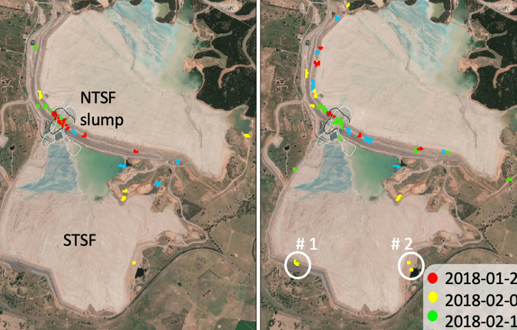
🛰 We demonstrate the power of our approach on a previously collapsed example of a tailings dam
A step towards our industry’s ambition for global monitoring capability, to make mining more sustainable.
VIEW ABSTRACT
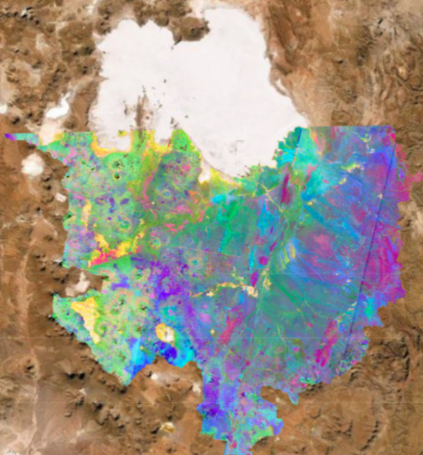
There is a critical need for a global monitoring capability for Tailings Storage Facilities (TSFs), to help protect the surrounding communities and the environment. Satellite Synthetic Aperture Radar Interferometry (InSAR) shows much promise towards this ambition. However, extracting meaningful information and interpreting the deformation patterns from InSAR data can be a challenging task. One approach to address this challenge is through the use of data science techniques. In this study, the representation of InSAR metadata as Entity Embeddings within a Deep Learning framework (EE-DL) is investigated for modelling the spatio-temporal deformation response. Entity embeddings are commonly used in natural-language-processing tasks. They represent discrete objects, such as words, as continuous, low-dimensional vectors that can be manipulated mathematically. We demonstrate that EE-DL can be used to predict anomalous patterns in the InSAR time series. To evaluate the performance of the EE-DL approach in SAR interferometry, we conducted experiments over a mining test site (Cadia, Australia), which has been subject to a TSF failure. This study demonstrated that EE-DL can detect and predict the fine spatial movement patterns that eventually resulted in the failure. We also compared the results with deformation predictions from common baseline models, the Random Forest model and Gaussian Process Regression (GPR). Both EE-DL and GPR greatly outperform Random Forest. While GPR is also able to predict displacement patterns with millimetric accuracy, it detects a significantly lower number of anomalies compared to EE-DL. Overall, our study showed that EE-DL is a promising approach for building early-warning systems for critical infrastructures that use InSAR to predict ground deformations.
Bayaraa, Maral, Cristian Rossi, Freddie Kalaitzis, Brian Sheil. ”Entity Embeddings In Remote Sensing : Application to Deformation Monitoring for Infrastructure.” Remote Sensing (2023),15(20), p.4910.

How does satellite-InSAR compare to traditional geotechnical approaches?
The first systematic demonstration of the complementarity of ground deformation monitoring for a failed TSF case study using satellite InSAR, finite element modelling and ground-based prism data.
VIEW ABSTRACT
In this paper, ground deformation measurements from synthetic aperture radar interferometry (InSAR) and ground-based prism monitoring are compared to finite-element (FE) simulation results for a recent tailings dam collapse. The InSAR monitoring demonstrated the complex spatial and temporal variability of the tailings dam deformation that is not captured in traditional, point-based monitoring approaches. Potentially anomalous deformation behaviour could have been detected from InSAR 1 year preceding the dam failure. A two-dimensional coupled-consolidation analysis was used to predict the dam behaviour during construction stages. The FE modelling results were in broad agreement with the deformation measurement sources, both in terms of magnitude and trends preceding failure. The results, however, deviate significantly immediately before failure, following the construction of the buttresses. Moreover, the FE modelling is sensitive to parameter uncertainties, such as spatial variability of foundation soil properties. The FE results revealed that deformation in both the upstream and downstream parts of the dam are sensitive to changing foundation properties. However, this impact is potentially much more significant on the downstream compared to the upstream parts of the dam, which are dominated by the behaviour of the tailings. This study highlights the efficacy and complementarity of geotechnical and remote sensing techniques for the monitoring of tailings dams.
Bayaraa, Maral, Brian Sheil, and Cristian Rossi. “InSAR and numerical modelling for tailings dam monitoring–the Cadia failure case study.” Géotechnique (2022): 1-19.
Link to publication in Geotechnique; accepted pre-print
Characterising a Lithium deposit from space
We explore how Li-brine deposits form, where the water and solute come from, how the brines are formed, and how abstraction affects the mass balance inside the salar. To support the entire system, open-source Earth observation data are analysed.
VIEW ABSTRACT
The demand for “green” metals such as lithium is increasing as the world works to reduce its reliance on fossil fuels. More than half of the world’s lithium resources are contained in lithium-brine deposits, including the salt flats, or “salars”, of the Andean region of South America, also known as the Lithium Triangle. The genesis of lithium-brine deposits is largely driven by the leaching of lithium from source rocks in watersheds, transport via groundwater systems to salars, and evaporative concentration in salars. The goal of this research is to create a consistent and seamless methodology for tracking lithium mass from its source in the watershed to its greatest concentration in the nucleus. The area of interest is in and around Bolivia’s Salar de Uyuni, the world’s largest salt flat. We explore how Li-brine deposits form, where the water and solute come from, how the brines are formed, and how abstraction affects the mass balance inside the salar. To support the entire system, open-source Earth observation (EO) data are analysed. We found that by constructing a flexible and repeatable workflow, the question of how lithium reaches the Salar de Uyuni can be addressed. The work demonstrated the importance of groundwater flow to the river network and highlighted the need for flow data for the main river supplying the salar with both water inflow and lithium mass.
Rossi, Cristian, Luke Bateson, Maral Bayaraa, Andrew Butcher, Jonathan Ford, and Andrew Hughes. “Framework for remote sensing and modelling of lithium-brine deposit formation.” Remote Sensing 14, no. 6 (2022): 1383.
Link to publication in MDPI Remote Sensing
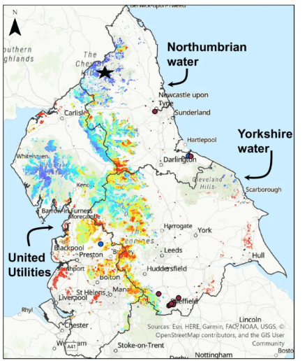
Natural Capital Accounting Case Study Using Satellite EO Data and the InVEST Tool
’I… a universe of atoms… an atom in the universe’ reflected the physicist Richard Feynman on our interconnectedness to our environment and each other. Because, ’when we try to pick out anything by itself, we find it hitched to everything else in the universe’ as the naturalist John Muir explained. In this blog post, we explore this interconnectedness through
an example case study of peatland ecosystems in the North of England…
Authors: Maral Bayaraa, Christophe Christiaen, Sarah Cheesbrough and Daniel Wicks. August 2023.

STATE OF AI 4 EO
Most of the images generated by satellites will never be seen by human eyes. There simply aren’t enough humans on Earth to sift through the TBs of imagery generated daily… ”
Artificial Intelligence is revolutionising many sectors, including our corner in Earth observation. What is the current state of research? How and where is it applied? What are the core ideas in deep learning for EO? Where are we going and what is the role of research and technology organisations?
Authors: Freddie Kalaitzis, Maral Bayaraa & Cristian Rossi. September 2022.

Input into UK Space Strategy Government Inquiry
Views on opportunities and challenges facing the EO sector. Recommendations are made for overcoming notable blockers that restrict the sector’s growth, stifling its potential to underpin game changing economic, environmental and social goods both in the UK and globally.
Authors: Dan Wicks, Cristian Rossi, Maral Bayaraa, Electra Panagoulia. June 2021.
Link to written evidence
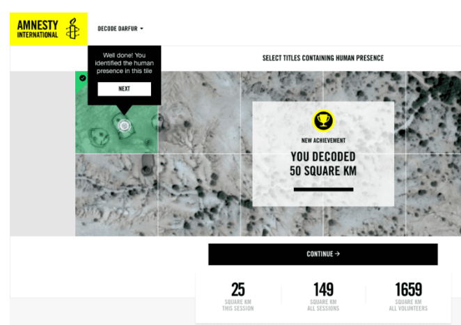
Using artificial intelligence to scale up human rights research: a case study on Darfur
In this article we provide a technical exploration of the potential of artificial intelligence for large-scale analysis of satellite data to detect the destruction of human settlements, with a case study on Sudan’s Darfur region.
Contributors: Milena Marin, Micah Farfour, Julien Cornebise, Daniel Worrall, Laure Delisle, Alex Kuefler, Denis Kochetkov, Alfredo Kalaitzis, Buffy Price, Sherif Elsayed-Ali, Tom Jones, and Maral Bayaraa. July 2020.

A PROBLEM SHARED IS A PROBLEM HALVED?
‘Maral Bayaraa travels down under to find out what a volcanologist, medic, geophysicist, geologist, forensic scientist and Earth/Remote Sensing expert have in common‘
ABSTRACT
The days of the lone genius are long gone. In my view, this is a hyperindividualistic ideal that overlooks the influence that sociohistorical events play in scientific innovation. Instead, we need to recognise the
global nature of our challenges and approach them with a multidisciplinary, multinational and collaborative spirit. Recently, I travelled to Fremantle, Australia, to attend a workshop that pushed this approach to its limits.
Regular Technology Open Forums are hosted by the mining giant Anglo-American (AA), where they unpack different stages of their mining lifecycle to see how they could approach mining differently more environmentally friendly, smarter, more efficiently and with less wasted precious resources such as water. This recent workshop was a cross-fertilization of experts from the space industry, medicine,
forensics and all the different shades of geoscientists.
So, what does a volcanologist have in common with a medic? A geophysicist with a space/remote sensing scientist? And geologists with forensic scientists? (no, this isn’t the set up to a bad joke). When we strip challenges down to their first principles, it is often the same fundamental problem, and more often than you may think, these have already been creatively addressed in other industries…
